
The forecast has been basically staying on track. Right now very cold air is slowly moving in. Combine the cold air mass with some cloud cover, and occasional snow showers, and we will struggle to warm up much more than where we are at right now. We fall into the 20s quickly tonight probably by 6PM tonight setting up for a hard freeze and icy roads this evening.
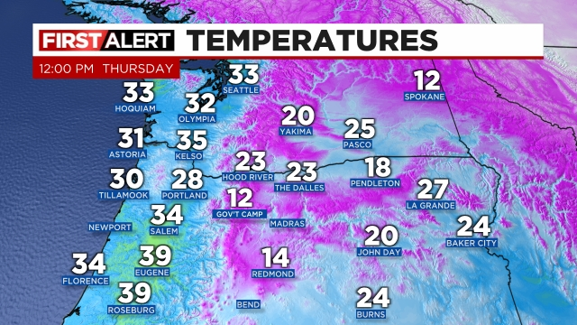
Here’s a quick look at temps as of noon across the region
Brrrr! Currently we are in a rather odd pattern. We have an arctic air mass moving south, but the low pressure system which brought us the snow is still sitting offshore to our southwest. If it was springtime, it is actually in the perfect spot for giving us downpours and thunderstorms. With the cold air in place I suspect some of us could see some heavy afternoon snow showers. Something to watch out for. You can see this happening on the satellite loop:
https://a.atmos.washington.edu/~ovens/wxloop.cgi?vis1km_pnw_color+12
And keep an eye on the radar to see exactly where these showers are. I could see another coating of snow happening on all surfaces later this afternoon/evening before we are “done” with the snow.
https://weather.cod.edu/satrad/nexrad/index.php?type=RTX-N0Q-1-24
Friday will be frigid! At least the first half of the day before the late February sun has a chance to moderate us a little. Lows both Friday and Saturday mornings will be somewhere between 15 and 20° and highs should top out in the upper 30s to around 40°.
We could see snow both Sunday and Monday mornings – two different setups, but same result lol. I’ll have another update this week regarding those two days, but it sure seems like we are not done with winter by a long shot. In fact all of next week and into the first weekend of March look extremely chilly!
Enjoy the cold and snow the best you can and stay safe!
