
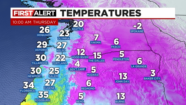
Brrrrrrrrrrrrrrr!!! It’s 25° outside at 10AM with a steady breeze and full cloud cover. Extremely impressive for our region to be so cold like this! Here’s the temps for the rest of the region as of 10AM:
Highlights
1.) Cold air will continue to blast through the Columbia River Gorge giving us a steady supply of arctic air. This means we will probably stay frozen until Saturday morning. We will NOT warm up above freezing until we see a switch in wind direction.
2.) A wintry mix of sleet and freezing rain will begin at some point this afternoon. Really hard to say when it will begin as a dry airmass like this can take longer than usual to saturate enough before the precip actually makes it all the way to the surface. Best guess is the sleet and freezing rain will start between 1 and 4PM.
3.) This is a colder but slightly drier version of the February 2021 storm. This is good and bad news. The good news is I expect less damage and fewer power outages. A number of people could still lose power – so be ready, but it will almost certainly be on a smaller scale as I’m thinking we see closer to half an inch of ice this time versus one and a half inches like last time. The bad news is our atmosphere is colder this go around which means roads will be terribly icy through Friday night most likely. It’s only 25 degrees during one of the shortest days of the year. It does not get much colder than this around here and the rain will have no trouble freezing onto the road surfaces when it arrives.
4.) We warm up Saturday; however, Portland and the gorge stay frozen until Saturday evening or even Sunday.
Lots of rain and wind next week, but again, let’s deal with one thing at a time.
Take care and be super safe out there!!
