There are multiple items peaking my interest this evening on the weather models. I have forecast details below including an update on the Cascades. Here’s our 7 day forecast for all of us visual people first. 😉
Details and Highlights
1.) Chilly showers tonight through Friday evening with snow levels dipping close to 1000′. Could see some ice pellets and or wet snow mixing in with the heavier showers.
2.) A powerful storm is set to move in on Saturday. Saturday will be a complete washout all day long. Winds will be strong during the early morning hours with gusts around 40 to 45mph. This storm will have quite the impact across the region with even stronger winds on the coast Friday night and Saturday morning (gusts up to 65mph), plus heavy mountain snow, and heavy rain in the lowlands. Expect some really terrible travel conditions this weekend.
3.) Very low snow levels Monday – Thursday of next week with several storm systems rotating through the region all while cool air is in place. What is certain is the Cascades are going to get hammered with a ton of snow. I’m fairly confident the Coast Range will see a quite a bit of snow as well.
4.) Notice I don’t have any snowflakes on the forecast yet. Right now I’m thinking it will be a little too “warm” for snow next week with the snow level staying above 1000′, but watch for new updates in case anything changes.
5.) Watch for black ice on roads this coming week as we flirt with below freezing temperatures, especially if we have some clearing during the nights.
The Cascades
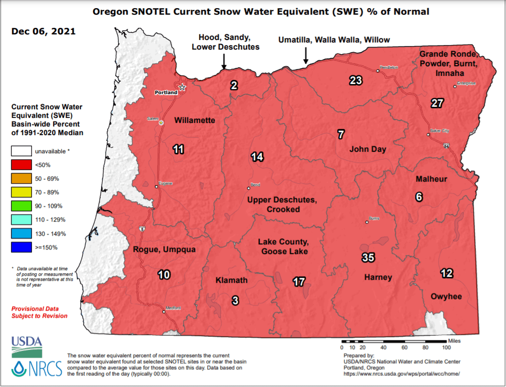
There was absolutely no snow at Hoodoo Tuesday afternoon. Mount Hood had a little in the upper most elevations, but all of this is just now beginning to change. First off, checkout just how awful our current snowpack is. As of Dec 6th the entire state was running way behind in the snow department. Fortunately, it is very early in the winter season, and as I mentioned things are changing.
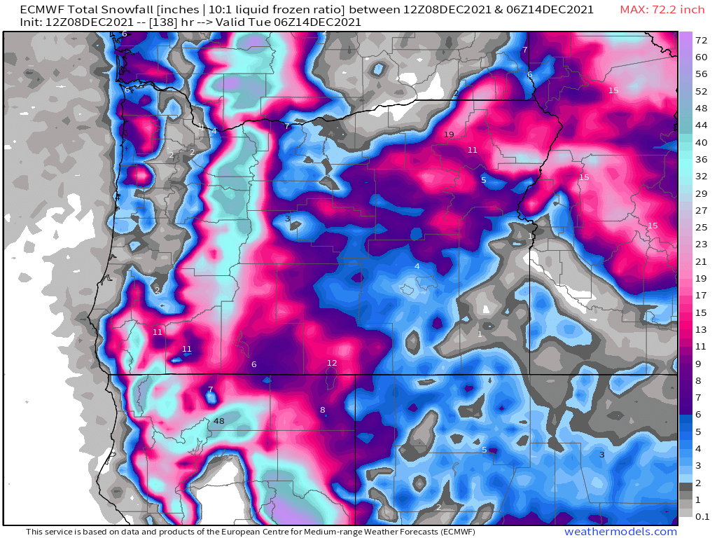
Now look at how much snow is expected to fall between now and Monday night.
Some 40 – 50 inches of snow up on the mountains in only 5 days!! That is a significant amount of snow in a fairly short timeframe. Travel across the mountain passes looks terrible this weekend, so use extreme caution if you find yourself headed that way.
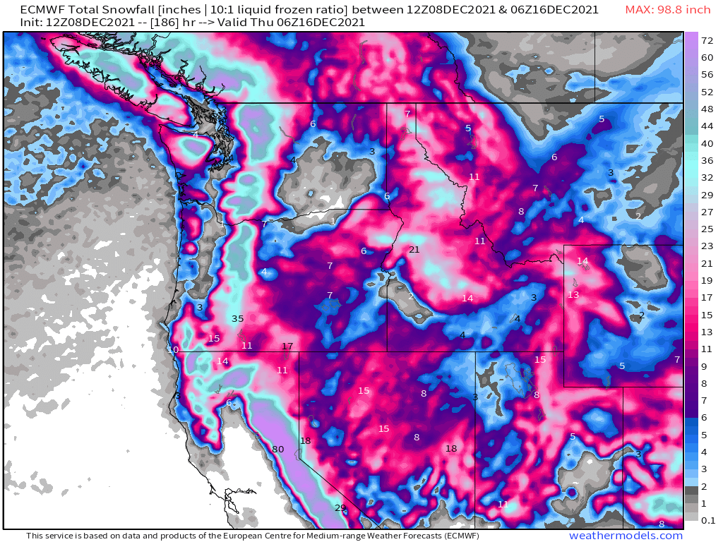
This parade of storms will bring much needed rain to both Oregon and California – even southern California. Meanwhile, the Sierra Nevada will see feet and feet of snow along with many of the mountain ranges out west. Overall a wonderful pattern for building the snowpack, restoring groundwater, and replenishing the drought stricken regions out here in the western US. This map shows snowfall for the entire west coast now through Wednesday.
The downside to this will be the adverse impacts on travel. I suspect we will hear of highway closures in the coming week as heavy snow blankets the mountain passes across the region. This will effect travel and the delivery of goods – another reason I am all about staying prepared with food and supplies at home. Okay, have a great evening, and keep an eye out for more updates as the weather is looking to stay active!


