
Quick update on this Sunday afternoon.
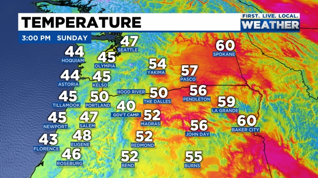
The forecast is still on track with a cold front moving through right now. Salem recorded a temp of 50° at 1PM and that will end up being our high for the day as colder air is already moving in from the northwest. You can see where temps stand as of 3PM with the coast being colder than central Oregon at the moment.
Snow levels drop down to 1000′ – maybe a little bit lower on the east side of the valley tonight as even colder air works its way down from the NW. Scenarios like this occasionally lead to “lower than expected” snow levels in east valley & foothill locations. Any lower than expected snowfall will be very short lived and minor, but don’t be shocked if you see a few slushy flakes mixed in tonight with the showers.
Monday should be a mostly dry day with just a few afternoon showers of rain, hail, and maybe some graupel. Graupel is really nothing more than a mixture of snow and ice pellets. Expect some of the showers to be rather heavy.
Nice dry and sunny weather looks like a lock for Tuesday and Wednesday before rain returns on Thursday through much of next weekend.
The Cascades
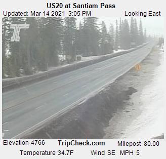
Passes turn snowy within the next hour and will stay fairly snowy through Monday morning with 3 to 6 inches of new snow. Santiam Pass has cooled 6 degrees within the last hour!
By Monday afternoon roads should be bare/wet as the increased energy from the March sun warms pavement up nicely this time of year.
Have a fantastic rest of your Sunday!!

I’m watching your cascade reports closely as I’m thinking about heading over the mountains this week!
LikeLike