
We have just under 2 hours of okay diving conditions before things turn bad and roads freeze over this evening. I want to emphasize again how this “second” storm will have much more of an impact than the one last night. Salem never rose above freezing today and we won’t. In fact we will probably cool off 2 – 4 degrees this evening back into the upper 20s. Brrrrr!!!!!! Here’s another temp update as of 4PM. Notice the bitterly cold air east of the Cascades and the sharp contrast in temperature from Salem to Roseburg where it’s a balmy 53 degrees!! It’s always amazing to see just how powerful the gorge can be in bringing cold air into the northern Willamette Valley.

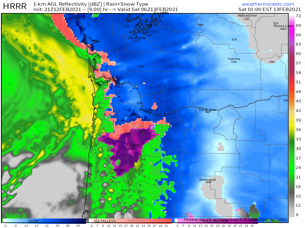
Freezing rain has been slowly accumulating on elevated surfaces and objects all day long as temps have not gone above 30. There’s a lot of freezing rain coming with this next storm system and I expect roads to freeze up quickly as soon as the sun goes down. I’m thinking half an inch to almost an inch of freezing rain will fall between now and noon Saturday which is going to take a major toll on trees and powerlines. I fully expect lot of power outages and downed trees tonight and tomorrow. Below is an estimated radar image for 10PM this evening. The dark pink and purple coloring around Salem indicates heavy freezing rain and with temps in the upper 20s. This is definitely going to end up as a top tier/historic February ice storm for Salem!
- Freezing rain should extend down to Corvallis and Albany, but I’m thinking those locations may warm up a little bit sooner on Saturday which could keep them from seeing as much ice as Salem.
- Snow could still mix in at times here in Salem the way it did last night in areas west and north of downtown, but overall freezing rain will be the main precip type.
- Roughly Wilsonville northward is still on track for some heavy snowfall. There will be areas of Portland that end up buried under a foot plus of new snow by this time tomorrow! This is shaping up to be a truly epic February snow and ice storm for our region!!
- Salem should rise above freezing Saturday afternoon at which point we should stay above freezing and begin to melt/thaw out.
- Portland may not thaw out real well until Monday, especially parts of the metro area that are located close to the gorge.
Okay, I think I covered everything. Be safe out there!!
