
I’m using the words “wintry” because currently it’s looking likely that we end up with regular rain, freezing rain, and maybe sleet, but not necessarily so much in the way of snow here in Salem. So much to cover and so little time lol, so let’s dive right in!
1.) A chilly, but very light east wind is already beginning near the Columbia River Gorge, and by Thursday afternoon it should be just blasting through the gorge transporting very cold air into our region. Right now the cold air is still making it’s way south and west towards us. Here are regional temps as of 9PM:

As you can see we have a long ways to cool before we will be cold enough for freezing rain or snow. This event will largely be gorge driven as that is where the coldest air will be coming from. The Portland metro area is always the more favored spot for seeing lots of snow in this setup, and to a lesser extent the west side of the Willamette Valley is also favored some as cold air blowing west through the gorge sort of pools up against the Coast Range.
2.) Light rain at times arrives Thursday morning. It will be a cold rain, but I expect Salem to stay above freezing during the daytime hours. Portland will likely freeze over around sunset give or take a few hours, so if your plans take you up there keep this in mind. Salem may not freeze up until some time between 9PM and 3AM early Friday morning.
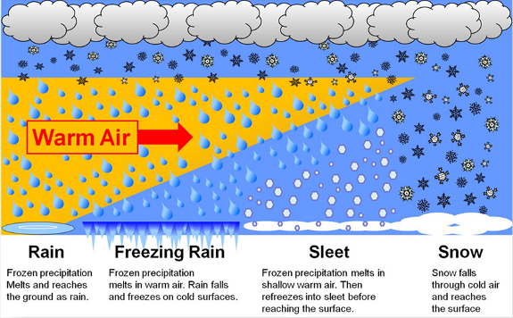
3.) The bad news is I’m not sure we will get very much snow. Salem will likely see mostly rain, freezing rain and maybe some snow mixing in occasionally. Snow chances increase the further west and north you live. In case you’re not sure how or what causes freezing rain check this graphic out below.
Basically the cold air Thursday night through Saturday won’t be deep enough for snow here in Salem as of right now.
5.) Storm number two comes in Friday afternoon through Saturday. This is the storm that should bring us the majority of our freezing rain and if things work out just right maybe some snow too.
FOR now, the most likely scenario I’m going with for now is we get plain old rain Thursday, and freezing rain Friday & Saturday with maybe half an inch up to 4 inches of snow and sleet mixed in. Could be a day were we switch back and forth between snow and freezing rain – what a mess!
Far less likely scenario is we see a lot of snow Friday & Saturday like 6+ inches. If the cold air overachieves and is deeper than expect then this scenario could happen which is why I’m mentioning it. Currently this is not expected to be the case.
Even less likely, but still technically possible is we end up with the coldest rain you’ve ever seen. This seems extremely unlikely based off of the trends I’ve seen, but if for some reason the cold air stalls just to our north we could be looking at a ton of 33 degree rain. Woo hoo!
Locations north of roughly Wilsonville will see significant snowfall of 5 to 12+ inches by Sunday morning. Locations between Wilsonville to roughly Salem will be in the messy and difficult to forecast rain, freezing rain and snow mix zone. Salem down to Albany should receive at least some accumulation of freezing rain Friday and Saturday, and again, very slight chance, but the chance exist that we see snowfall here if things work out just right (SLIM CHANCE THOUGH). With freezing rain likely the possibility exists for power outages, damage to plants, and lots of tree limbs down.
Phew!! I’m exhausted! Okay, time for a relaxing evening and I’ll give you all a nice update tomorrow morning or early afternoon!!
Take care!!!
