This title refers to both precipitation and temperature. We have had some very mild (mild by January standards) high temps. Two thirds of the way through the month and we are 4.4° above normal!!! Currently we are in one of our top 10 warmest Januarys on record. Yikes!! On the precip side of things it’s been a dry several of days; however, the first 12 days were unusually wet. Salem has had 6.88″ so far which puts us at 157% of normal for this point in the month.
Change is in the air
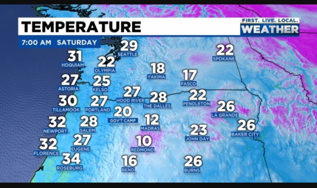
If you were up and outside this morning, then you likely noticed changes in our airmass have already begun to taken place. Check out the chilly morning temps around the region as of 7AM.
We are headed for a much cooler end to January. In fact this past week has already been a little bit cooler; however, even chillier air will work it’s way in over the next few days. Details below:

Highlights
1.) Sunday. Hmmm, I’ve seen and heard lots of rumors about snow this day, but meh, I’m not all that impressed. Unless something changes, I’m going with a very cold rain with snow mixing in at times. It’s possible that it falls as all snow early tomorrow morning for a little while, but it’s going to be extremely difficult for it to accumulate on the valley floor as temperatures are going to likely stay a few degrees above freezing. There’s a better shot at seeing a brief coating of snow 500 to 1000 feet – maybe up to an inch. A few inches of snow are possible above 1000′.
2.) Sunday night/Monday could possibly give a few of us a light dusting of snow if we’re lucky as Monday will be a colder version of our typical sunbreak and shower type of day. Still no chance of any widespread or major accumulation.
3.) Watching Tuesday and Wednesday very closely as a storm will be moving in from a more favorable direction. Favorable at least if you are rooting for valley snow. 😉 We will have cool air already in place and the storm moving in has a bit of cool air with it as well. Of course we need just about everything to line up just right for snow around here, so don’t get too excited yet. At this time, Tuesday is looking like it could be our best shot at sticking snow this entire winter…
4.) The rest of next week we stay in a very low snow level pattern with lots of snow in the Coast Range, the Cascades, and the foothills around the valley. A very chilly and wet pattern for sure. Great for building the snowpack!
I’ll be updating much more frequently this coming week, so keep an eye out for those and keep an eye out for some snowflakes. 🙂
Take care and stay warm!

