I hope you all are enjoying the holiday season! Even with everything going on there is still much to be thankful for and much to enjoy. Just some quick words of encouragement from your local weatherman. 😉 Okay, moving on we have several dry or mostly dry days ahead with no sign of any big storms or arctic blasts, so with not much going on I figured it was a good time to recap November.
Highlights
November 2020 was not real exciting in terms of weather events. We had several days of wind & rain including a peak wind gust of 43mph on the 13th, but very few really wet storm systems. Perhaps the biggest highlight of the month was the good start to the mountain snow season up in the Cascades. It’s been several years since we have seen an early start like this. As of Monday, Hoodoo had 34 inches of snow which is well above normal for the end of November!! The final thing worth noting from the month would be the higher than normal amount of dry days (both foggy and sunny) which helped to keep our precipitation for the month slightly below normal.
Temperature
Warmest high temp was 68° November 4th
Coldest high temp was 39° November 27th
Warmest low temp was 58° November 4th
Coldest low temp was 24° November 9th
8 days with lows at or below freezing.
It’s been awhile, but we finally had a cooler than normal month. November 2020 was 1.1° below normal.
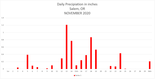
Salem had 19 days with measurable precipitation with most of the action taking place mid month, but as mentioned, not very many wet storm systems at all. The wettest day of the month was the 13th with 1.21” of rain. We ended November with 5.89″ of precip which is 90% of our average for the month, so yet another drier than average month.
Looking ahead
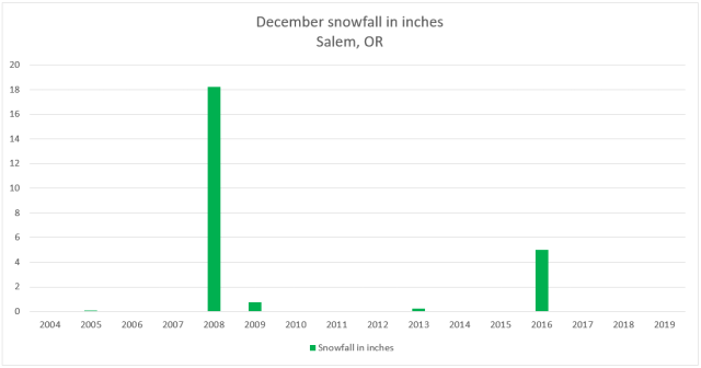
December is typically our wettest month of the year and one of our coldest. We will see what happens, but early indications are hinting at a cooler than normal month. As far as snow goes, December has not exactly been a big snow producer around here as of late. In fact, over the past decade February has actually been our snowiest month on average. Curious to see if that stays the same this year or if we get some good snowfall during December or January instead. Anyway, check out this graph of December snowfall going back to 2004.
Really only 2 years with any decent snowfall on this chart. I’m sure a lot of you remember 2008 when it snowed and snowed and snowed leading up to Christmas. More recently in 2016 we had a nice December snowstorm, but overall December snowfall has not been all that common lately. With that said, our chances seem to increase slightly during a La Nina. Take it for what its’ worth, but I’m thinking we see some snow this December. Just my gut feeling… 😉
Happy December!!!


