Another stretch of above average temps will arrive tomorrow and will last through Wednesday of next week.
As you can see, plenty of hot weather, and aside from a very slight chance for a shower or two on Thu & Fri, no decent shot at rain in sight, and if we look even further out it appears as though August will start off on the warm and sunny side.
The Cascades and Central Oregon
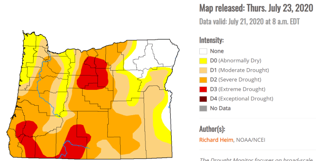
Thunderstorms are possible in the Cascades Mon – Wed with the threat extending into Central Oregon Tue & Wed. This could spell bad news for wildfires as we have been dry now for awhile. Here’s a look at our current drought status. Most of the state is running below normal in regards to precipitation.
Central Oregon Coast
The forecast for the coast in summer can be so dang tricky, but I figured I ought to give it shot just in case any of you are fortunate enough to make it over there. 😉 Sunday should be the warmest day along the beaches with close to full sunshine, but it will likely be fairly breezy. Mon and Tuesday will likely be much cloudier and consequently a bit cooler, but not quite as windy. Slight chance for some light rain showers Thursday and Friday along with even cooler temps.
There you have it!
ENJOY!!!


