Wintry weather is still on the way and there are a few changes to highlight.
First big change: the odds of accumulating snow Monday night through Tuesday morning have increased a bit since my last update. It’s looking more likely that we will see a snow day on Tuesday. Not a slam dunk yet, but higher chances than what was indicated in my previous update.
Second big change: the Wed/Thu storm has been trending more like a quick hitter meaning a snow day Wednesday is still fairly likely, but by Thursday morning it’s possible we switch to southerly winds for a quick warmup. This storm is several days away still, so I expect this to change at least a few more times before landing on a final solution. I should have a much better idea of what will happen for this storm by Sunday night.
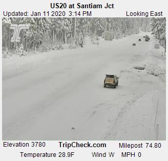
Meanwhile the Cascades are just getting dumped on. Hoodoo has over 50 inches of snow currently which is a lot considering one week ago they only had 15. Heavy snow will continue pretty much nonstop now through Tuesday with another 3 or 4 feet falling at pass level. Here is what the chain up area looked like around 3:00pm:
A more detailed update later tonight with specifics concerning Monday and Tuesday.


Thank you for the update!
LikeLike