There has been a lot going on lately with the weather and I figured it was past time to get all caught up. We are looking at one of the wettest Aprils on record, snow in the mountains, and intense flooding across the area. Flooding in the Willamette Valley has been the worse since January 2012, and in some places all the way back to November 1996! Right now Salem is 3 inches above normal for rainfall at this point in the month.
This picture was taken on Wednesday. It shows highway 34 crossing the Willamette River on the eastern edge of Corvallis. Very high water levels will continue for another day or two.
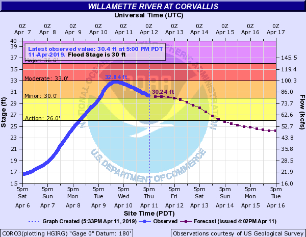
This is a chart of the Willamette’s river level in Corvallis. It crested at 32.8 feet. For reference the February ’96 flood crested at 33.5 feet down there. Pretty incredible!
Extended Forecast
I’ve got an updated extended forecast here for you as I’m sure you’ve all been struggling through life without one over the past several days 😉
Details
Fairly high confidence with the exception of Tuesday and Wednesday. Both those days could be wetter or drier than currently forecast. Right now I’m sorta splitting the difference and banking on Wednesday being a drier day while Tuesday stays on the showery side of things.
High confidence that we enter into a dry spell stating next Wednesday/Thursday, and there are indications that this dry spell will last through Easter weekend 🙂
In the meantime we have several more cool and showery days ahead. I’ll leave you with this snowfall map showing a solid 10 to 20 inches of new snow for the Cascades by the end of Tuesday with the highest amounts above 5000′. Winter is trying hard to hang on.


