
The forecast seems to be on track thus far which is making me pretty happy. As expected, temps across the mid valley were between 32 and 35 degrees this morning depending on elevation. In fact elevation made all the difference in the world concerning who saw snow and who didn’t. Here are some images of the road conditions from earlier. If you are familiar with these streets then you will notice south Salem in particular was a winter wonderland this morning while the rest of Salem & Keizer had almost no snow on the ground with the higher west Salem hills as the only exception.


The rest of today and tonight: A few more snow showers will roll in through the course of the afternoon, but they will not stick as we are a bit above freezing now; however cold air is pouring down from Canada and by 4 or 5pm I expect us to be back down to near freezing. Anything that falls after that point in time should stick, so plan on icy roads starting this evening.
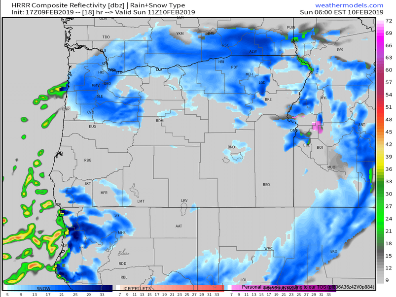
I’m forecasting a decent chance for widespread snowfall tonight as we will have a fairly similar situation to the one that brought us snow earlier this week. I’ve posted the simulated radar for roughly 3AM. You can see a nice band of snow directly over us. We will be plenty cold by this point, so I’m going with ½” – 2 inches for everyone.
Sunday: we wake up to a frozen landscape with temps in the low to mid 20s. It will be a slow thaw as we creep towards freezing by the late afternoon.
Sunday night: Another storm rolls in which should start out as snow, but will very quickly switch over to rain leaving us with a slushy dusting to an inch at best.
Monday: I now fully expect Monday to be a cold rainy day with breezy south winds. Our regular school and work schedules will most likely be just fine this day.
Monday night/Tuesday: This is a major storm with estimated total precip being around 1.5 – 2”!!! Now a lot of that is probably going to be rain, but if we are somehow colder than expected this could be a huge snowstorm. For now I’m thinking we start with some rain change over to a heavy wet snow and then during the day Tuesday we make the switch to freezing rain (briefly) and then just plain old rain. Tuesday is going to be a rough day for anyone trying to travel. I’m thinking 1 – 4” for the valley floor with 2 – 6” for the higher hills around town, and up to a foot plus above 1000’. In addition to that we will likely see up to an inch of rain on top of that Tuesday afternoon which could make for some localized flooding.
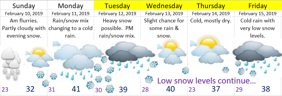
Beyond Tuesday we stay in a very cold and wet pattern setting us up for more snow events/storms…
