
I’ll start off with this awesome pic showing the capitol mall coated in white after Monday night’s little snow storm.

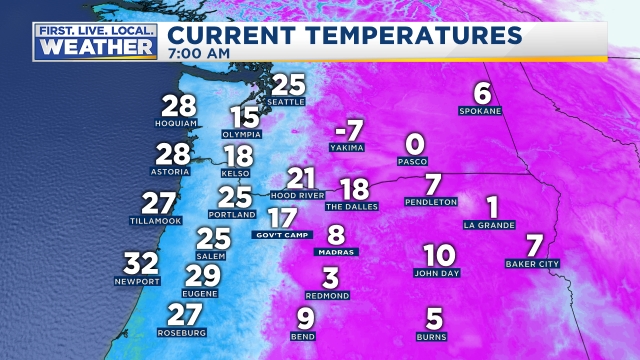
That was a nice little snow event. It appears as though almost everyone received between one and two inches of snow with a little less on paved surfaces. Since then we have stayed much colder than normal. This morning we experienced by far the coldest temperatures of the winter. Look at the bitter cold east of the Cascades!! -7°F in Yakima!
We are in the beginning of what looks to be a very prolonged stretch of cold and snowy weather. The “storm” this past Monday night was just the warm up event. If you’re in a hurry I’ve got the 7 day forecast right here followed by the parts of the forecast I’m feeling most confident about. When you’ve got more time take a look at the important details further down.
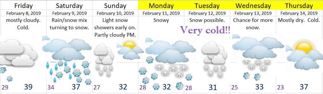
First off notice many of the days are highlighted in yellow indicating low confidence specifically in regards to the paths of the storms. The very cold air is certain, but what’s not as certain is how much moisture will fall with each storm and where exactly will each storm go. Something to keep in mind as big changes to the forecast are possible over the next few days especially for Tuesday & Wednesday of next week.
High confidence
Much colder than normal temperatures will continue for the better part of the next two weeks, and possibly even beyond than that.
Multiple opportunities for widespread snowfall. I would say between Friday night and this time next week Salem should at a minimum see 3 to 6″ of snow, and it’s definitely in the realm of possibility we see much more than that.
Lots of snow above 1000′, in the Coast Range, and up in the Cascades.
Lots of snow through the Gorge. In fact, don’t be surprised to see I-84 closed more than once over the course of the next couple of weeks along with other highways around the state.
All the Details
Friday: The calm before the storm(s), and perhaps the last day roads will be completely snow and ice free for a week, maybe even longer.
Saturday: A very interesting day as we should start off very early in the morning with rain before changing to a rain/snow mix around lunchtime & finally changing to all snow by evening as arctic air rushes in from the NE. I’ll be closely watching the snow levels as they are predicted to not rise much above 1000’, so if precip is heavy enough and/or if temps are a little bit cooler than we could see more snow than current predictions indicate. We will start the day in the mid to upper 30s before falling into the upper 20s by midnight. Snow totals: 1 – 2” for the valley floor. 2 – 3” around 500’. 3 – 6” above 1000’.
Sunday: Very early morning snow showers with lows in the 20s giving way to partly cloudy skies and highs near 32°. Snow moves back in Sunday night. Snow totals: nothing – 1”.
Monday: Snowy much of the day with highs staying below freezing. Snow totals: 2 – 5” for the valley locations. Up to 8” above 1000’.
Tuesday: More snow likely. Just not sure how much yet. There’s lower confidence on the track of this storm which is why I am less certain regarding snow totals; however, what I do know is a very cold air mass will be over us. I’m going with high temps between 29 and 32 degrees. Very cold!!
Wednesday: Similar to Tuesday. The possibility is somewhat high that we see several inches of snow between Tuesday & Wednesday. I should have a much better idea in a day or two.
Thursday: Cold and mostly dry.
