
Who got snow and who didn’t…
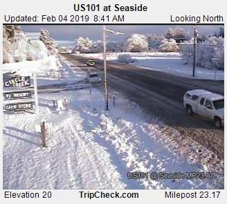
As always “the devil is in the details” lol… It looks like the east side of the valley did in fact do slightly better in terms of snowfall (and they could get more), especially considering Salem has nothing still. The Coast is the biggest winner so far with many locations north of Lincoln City receiving 1 to 4 inches of snow. Even down to sea level!! This pic of highway 101 near Seaside from earlier really shows the winter wonderland over there.
Since Salem once again missed out on the snow I thought I would share this collection of pics from locations around the region to help ease the pain 😉
*The pic with the red truck was taken along at the coast near Astoria, the beach pic is Haystack Rock, the ruler pic is from Cannon Beach, & the snowy house is from Washougal.*
ENJOY!
A quick recap of our “storm” so far
The Good
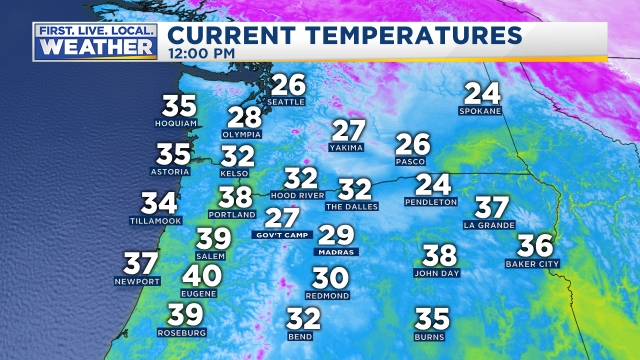
Cold air aloft had little trouble making it here. I understand it’s not crazy cold down here in the valley, but you don’t have to travel far to find temps below freezing.
Here are the temps around the northwest as of noon. A very chilly air mass!! Look at Seattle still in the mid 20s! That’s some cold arctic air just to our north!
The forecast for the coast and Coast Range worked out very well with all those areas receiving snow and in some places a bit of it.
Forecast for the east side of the valley went okay. Not as much snow as I predicted, but in general east side locations like Stayton and Scio all ended up with a dusting which is more than Salem got, so I’m giving myself a passing grade on this part of the forecast.
The bad and the ugly
Not enough moisture. Many of the weather models and consequently myself overestimated the amount of precip that would make it into the valley. If you want snow in a pattern like this then you need heavy or steady precip to literally help “pull the cold air down.” Yes, that’s actually a real thing as steady precip often times forces & brings cold air down with it from higher up. This is exactly what happened at the coast which is why they ended up with snow and we didn’t. I banked my forecast on at least a few more showers making it over the Coast Range and that did not happen. 😦
So what’s ahead?
A weak band of precip will slide primarily along the east side of the valley producing snow in the air. Snow will not stick due to the “heating of the day,” but if the precip can stick around into the evening hours than locations like Silverton, Canby, Molalla, Scio, and Stayton/Sublimity could all see a dusting of snow. Emphasis on no more than a dusting as I don’t see a lot of moisture to work with, plus we are several degrees above freezing currently.
Possible game changers
- Depending on where the precip band shifts we could see no snow even in the air or more snow if it moves close to us.
- If moisture is heavier than forecast we could end up with a nice snowy night tonight.
Looking further ahead
Tuesday – Thursday: Vast majority of this time will be dry. A light rain or snow shower is possible Tuesday afternoon & evening, but that’s it. Partly cloudy skies should rule the day. Just keep in mind it’s going to be chilly.
Friday – Sunday: Closely watching for a better opportunity for widespread and possibly significant snowfall. None of this hit or miss weak shower stuff. More to come on this potential tonight or tomorrow.
