
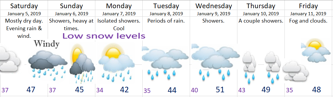
Highlights
Very active weather on tap for the entire Willamette Valley these next several days.
First things first, we have a pretty strong wind event headed our way Saturday evening into early Sunday morning. Wind gusts should be in the 35 to 50mph range with chances that they go a little higher or lower depending on the exact track of the storm. Regardless it will be a rainy and windy night. You can see the storm on the visible satellite right here. Very impressive looking!!

Sunday will be chilly & breezy with cold showers streaming onshore. Could even see a hail shower or two.
Sunday night & Monday will be even chillier with a couple showers left over. Snow levels will only be around 1000’ (possibly lower). This means the Coast Range and Cascade foothills could see some snow (1 – 3”). The snow potential does not affect the Salem area at this time…
Here’s just one of the many snow maps I look at to help make my forecasts. This is total snowfall in inches ending Tuesday night.
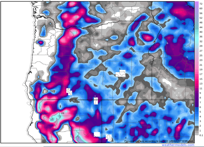
Take away message:
- Cascade passes will be snowy Saturday night through Tuesday morning.
- Coast Range will be seeing snow at times Sunday – Tuesday AM.
- Foothills down to 1000′ will see an inch or two Sunday night/Monday morning.
Tuesday could be a bit interesting with a warm front pushing up from our southwest bringing plain old rain, but with cool air in place I could see the foothills and Coast Range communities start out with a brief snow or ice mix before changing to rain. Something else to keep an eye on.
Wednesday & Thursday: Lots of clouds with a few showers.
Friday: Foggy & mostly cloudy.
Feel free to track the storm on satellite with link: http://rammb-slider.cira.colostate.edu/?sat=goes-17&z=1&im=14&ts=1&st=0&et=0&speed=50&motion=loop&map=1&lat=0&opacity%5B0%5D=1&hidden%5B0%5D=0&pause=20190104193219&slider=-1&hide_controls=0&mouse_draw=0&follow_feature=0&follow_hide=0&s=rammb-slider&sec=conus&p%5B0%5D=geocolor&x=4458.13330078125&y=4418.933349609375
More updates to follow, so stay tuned!!!!
